January 2021
Climate and weather patterns of the Lebombo Concession
Share:
Climate and weather patterns of the Lebombo Concession
The Singita Lebombo Concession lies in the central area of the Kruger National Park, on the eastern boundary of the park where South Africa borders with Mozambique. This international border runs along the top of a ridge of hills known as the Lebombo Mountains (although they are not mountains, but rather a ridge of hills), which run from north to south. The Kruger National Park lies in an area of South Africa known as the ‘Lowveld’. It is called the Lowveld due to its low altitude, ranging from around 300 – 600 m above sea level. To the west of the Lowveld is the Transvaal Escarpment or the Transvaal Drakensberg Mountains. These are actual mountains, as opposed to hills (the peak known as Mariepskop lies at 1 945 m above sea level). To the west of the escarpment lies the great central plateau of South Africa (Johannesburg and Pretoria are located on the so-called ‘Highveld’. Johannesburg lies at an altitude of 1 750 m and Pretoria at 1 300 m). On the eastern side of Mozambique lies the warm Indian Ocean. The southern-most part of the Kruger National Park lies approximately 85 km / 52,6 miles from the ocean, whereas at the northern point of the Kruger National Park the ocean lies 420 km / 260 miles away (in a straight line to the east). Therefore, the further north one goes in the Kruger National Park the further one is from the ocean. The Kruger National Park is approximately 350 km from north to south and is on average 60 km / 37 miles wide. It covers 2,2 million hectares (excluding the private game reserves and other wild areas to the east and west of the park). The Tropic of Capricorn runs across the park approximately two-thirds of the way up the park.
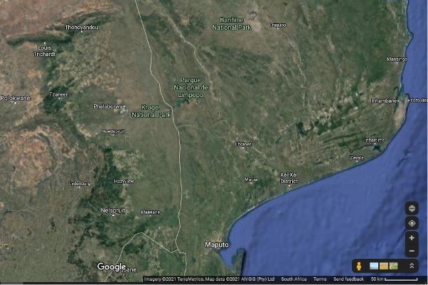
In the satellite image above one can see the Kruger National Park, with the international border with Mozambique. Singita Lebombo lies in the eastern centre of the Kruger National Park between the wording ”Kruger National Park” and “Park Nacional de Limpopo”. The warm Indian Ocean can be seen to the east of Mozambique. To the west of the Kruger National Park one can see a green patch extending northwards near the areas listed as ‘Nelspruit’, ‘Hazyview’, ‘Tzaneen’ and ‘Louis Trichard’. This green patch is caused by the forests that grow on the eastern side of the escarpment. To the west of this lies the great Central Plateau of South Africa / the Highveld. – screengrab from www.google.com/earth.
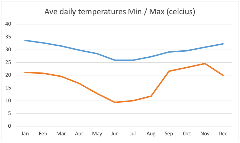
The Lowveld has subtropical climate with hot, humid summers and mild, dry winters. During summer midday temperatures can exceed 40 degrees Celsius / 104 degrees Fahrenheit. At night, in summer, temperatures seldom drop below 20 degrees Celsius / 68 degrees Fahrenheit. During the winter months midday temperatures average around 26 degrees Celsius / 79 degrees Fahrenheit and at night temperatures seldom drop below 5 degrees Celsius / 41 degrees Fahrenheit.
The Lowveld does not receive a lot of rain each year and the rainfall can be erratic, varying greatly from year to year. Based on its latitude position, the park falls into a high pressure area known as the Horse Latitudes. (The Horse Latitudes occur just south of the Tropic of Capricorn in the southern hemisphere and just north of the Tropic of Cancer in the northern hemisphere). According to Wikipedia, “the horse latitudes are an area of high pressure at about 30° to 35° latitude where winds diverge into the adjacent zones of Hadley or Ferrel cells, and which typically have light winds, sunny skies, and little precipitation”. These latitudes coincide with a zone of dry, descending air (particularly during our winter months). High pressure cells do not generally allow for rain to form. The majority of the deserts in the world, including the Kalahari and Sahara Deserts are found in the horse latitudes. During our summer months these high pressure cells lift and move south allowing moist air to move into the area from the ocean and even allow the moisture to reach the interior plateau of South Africa.
The Kruger National Park therefore falls in a summer rainfall area and receives very little precipitation during the winter (June, July, August) months. The average rainfall for the Kruger National Park is approximately 500 mm per year. The south western corner of the park receives the most rain as it lies closest to the escarpment. Moist air is blown in from the warm Indian Ocean (the Agulhas Current). When it hits the escarpment the rising air (going over the mountains) causes precipitation to form (as the air rises it cools and the moisture condenses). As one moves further north in the park one gets further away from the escarpment (and further away from the ocean) and therefore the further north one goes the less rain can be expected. The far north of the park receives the least amount of annual rain. The majority of rain that we receive in the park is not orographic rain (rain caused by moist air moving up and over mountains) though, but rather convectional rainfall.
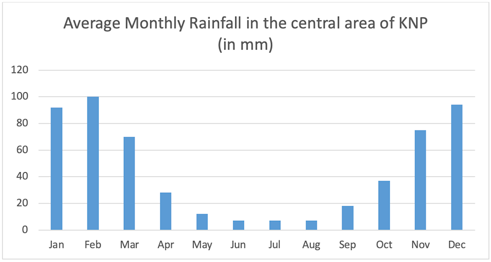
Based on figures by compiled N Zambatis, Scientific Services, Kruger National Park (1961-1990)
Convectional rainfall occurs when the earth and water bodies are heated causing rising thermals. These thermals carry moisture in the form of water vapour. As the water vapour rises it starts to cool until it condenses (in the same way that orographic rain forms). Clouds then form and rainfall may occur. Convectional rainfall often occurs in the form of thundershowers, which may be accompanied by thunder and lightning.
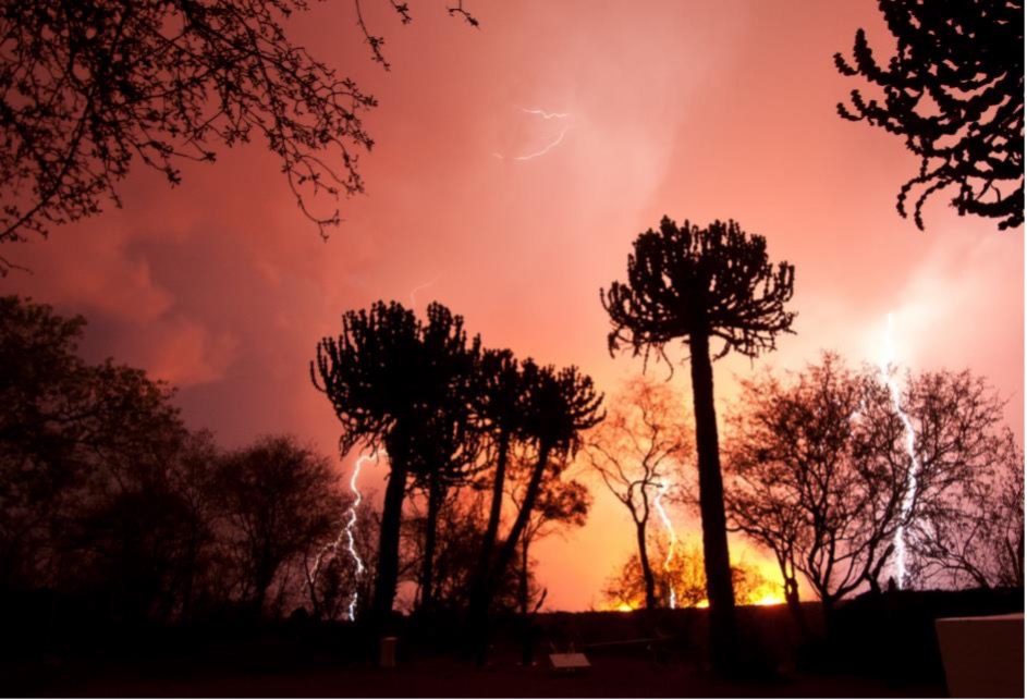
During our summer months we do, on occasion, experience storms with massive cumulonimbus clouds and fantastic lightning displays. If we receive lightning storms in late spring (November), when the grass is still dry and the rains have not properly fallen yet, the bolts of lightning can cause veld fires to spring up and burn the bush.
Another form of rainfall that we receive here in the Lebombo concession and in the Kruger National Park is Frontal Rainfall, which occurs when a cold front moves up along the coast (usually from Cape Town) and rarely reaches KwaZulu-Natal and the Lowveld. The cold air pushes underneath the warmer air as it moves up along the coast causing the warmer air to rise and therefore cool and condense to form rain. This type of rain generally occurs as cold, light rain that may last a day or two. We sometimes receive this type of rain during our winter months, although it is not common for the cold fronts to travel all the way up the east coast and affect areas as deep inland as the Kruger National Park.
Research on the rainfall patterns in the Kruger National Park over the last 100 years indicates a cyclical tendency in rainfall volumes, with 10 years of above average rainfall typically followed by ten years of below average rainfall. The past 10 years are regarded by many as one of the most intense droughts experienced in the history of the Kruger National Park. Are we now likely to experience ten years of above-average rainfall? Perhaps… on the 22nd of January Cyclone Eloise made landfall in Mozambique.
South Africa is not a country known for hurricanes, typhoons or tropical cyclones (as they are known in this part of the world). It is very seldom that we experience these intense storms. Fortunately, our eastern coastline, where the ocean-current is warm, is fairly well protected by the island of Madagascar and the Atlantic Ocean on the western side of the country is a cold ocean and therefore not conducive to the forming of large low-pressure cells and cyclonic activity. Tropical cyclones only affect South Africa during the summer months (and usually only in January or February). Only tropical cyclones that move into the Mozambique / Agulhas Channel (i.e. the channel between Madagascar and Africa) influence South Africa’s weather. Very few cyclones manage to go around Madagascar and come close enough to South Africa to cause problems or destruction, and then usually only north of the 25°S latitude. Where cyclones do manage to affect South Africa only the areas such as the Limpopo Province, Mpumalanga and KwaZulu-Natal may experience destructive winds and the risk of flooding.
Cyclone Eloise as it hit Mozambique on the 22nd / 23rd of January 2021. Image from www.windy.com.
In January and February of 1984 Cyclones Domoina and Imboa respectively caused largescale flooding and human deaths (Cyclone Domoina caused deadly flooding in south-eastern Africa that killed 242 people and caused an estimated $199 million in damage). In the year 2000 a Tropical Cyclone Leon-Eline came over Madagascar and crashed into the coast of Mozambique. Shortly after hitting Madagascar another tropical storm Gloria also hit the island. Together the two storms caused an estimated $9 million worth of damage in Madagascar, killing at least 205 people and causing another 10 000 people to become homeless. When Eline hit Mozambique it caused more damage. It was estimated that 329 000 people were displaced, at least 700 people were killed, more than 250 000 hectares of crop fields were destroyed and the economic damage was estimated to be more than $500 million in total. In 2019 Cyclone Idai hit Madagascar and southern Africa. It was estimated that more than 1 000 people died in Mozambique alone and that the total damages from Idai across Mozambique, Zimbabwe, Madagascar, and Malawi were estimated to be at least $2.2 billion, making Idai the costliest tropical cyclone in the South-West Indian Ocean basin (Figures from Wikipedia).
On the 22nd of this last month Cyclone Eloise made landfall in Mozambique, after hitting Madagascar. Although it was nowhere near as destructive as the cyclones mentioned previously it did bring with it huge amounts of rainfall. Here at Lebombo we only experienced the southern-most tip of the cyclone. On the 25th of January a front travelling up the coast of South Africa started pushing even more moisture into the interior and towards the Kruger National Park and we were expecting heavy rain to fall in the concession. This did not happen though. The cyclone veered northwards affecting the northern part of the park and the cold front that came up the coast caused heavy rain to fall in the south of the park. In the central area, where we are located we were spared the heavy rains.
With all the rain from the cyclone and the front both the N’wanetsi and Sweni Rivers started flowing. The water in the N’wanetsi pushed over the weir and causing the river in front of Lebombo Lodge to flood its banks. Fortunately, the lodges were safe. What an amazing sight!


By Brian Rode
Senior Field Guide